Publishing the Eastern Korinthia Survey

One of the long-standing projects I have been working on over the last year is a book-length publication interpreting the results of the Eastern Korinthia Archaeological Survey. EKAS was a survey carried out from 1997-2003, with study seasons continuing to recent years. Unlike the more common survey project carried out in marginal territories or regions of small city states of antiquity, our work focused for the most part on the Isthmus of Corinth, one of the busiest and materially richest landscapes of antiquity. Although we made some forays into the southeastern region (with their own surprising results), our main work was on the Isthmus. That work has never been published in a systematic way. With the generous support of the project directors, I began last year to write up the results of the distributional survey.

Fieldwalkers line up on the Isthmus of Corinth in the first season of the EKAS Project in summer 1999

I spent a lot of time in fall refining survey data and also wrote the preface and six chapters. While I have some heavy lifting ahead of me (several period chapters still to write), I estimate that I’ve drafted about 70% of the work at this point — which puts the conclusion well within reach. Over the course of the year, I’ll be floating sections of the manuscript via this site and also writing a bit about some of the challenges of working with legacy data in artifact rich environments. For now, I include the table of contents and the opening part of the preface.

Table of Contents:

List of Illustrations ………………………………………………………………………………………………….  

List of Tables ………………………………………………………………………………………………….  

Preface ………………………………………………………………………………………………….

1. EKAS: A Twenty-Year Retrospective………………………………………………………………………………………………….

2. The Character of a Distributional Survey………………………………………………………………………………………………….

3. Archaeological Datasets………………………………………………………………………………………………….

4. Reflections on Surface Scatters……………………………………………………………………………………….

5. Patterns of Artifacts, Settlements, and Land Use……………………………………………………………………………………….

6. The Prehistoric Corinthia……………………………………………………………………………………….

7. The Protogeometric to Hellenistic Corinthia………………………………………………………………………………………………….

8. The Roman Corinthia………………………………………………………………………………………………….

9. The Medieval to Ottoman Corinthia………………………………………………………………………………………………….

10. The Modern Corinthia………………………………………………………………………………………………….

Preface:

Nearly two decades have passed since American archaeological field teams completed a major systematic survey of the eastern territory of the city of Corinth. The project, known as the Eastern Korinthia Archaeological Survey, involved over one hundred archaeologists, historians, geomorphologists, and student volunteers collecting cultural and environmental data over a span of six summers (1997-2003). As the first large-scale, intensive systematic survey of the Isthmus and Corinth’s southeastern territory beyond Mt. Oneion, EKAS promised to make significant contributions to Corinthian studies and the broader scholarship of Mediterranean landscape archaeology. The survey of the immediate territory of a major city of classical antiquity was unique in comparison with the more common studies of rural and remote regions of small Greek poleis. The project’s early adoption of innovative methods and tools, including tract-level mapping of artifacts, geomorphological assessments, an operative GIS, and database applications, made it significantly more intensive than other surveys in its day.

A formal and comprehensive publication was scheduled to appear in the years following fieldwork, but problems of execution and interpretation stalled immediate dissemination, while the project’s successes, including major new discoveries, generated trajectories of fieldwork that ultimately deferred analysis and publication. An important multi-authored preliminary report on the project’s methods came out in Hesperia in 2006 hinting at future sequels. An impressive array of individual publications appeared, offering discrete interpretations of particular sites or periods. The idea of a formal publication resurfaced again in 2015 as I was finishing my historical study of the Isthmus of Corinth and gained traction as we approached the twenty-year anniversary of the start of the survey. A plan was devised at last in 2018 with the support of the project co-directors (Timothy Gregory and Daniel Pullen), the field director (Thomas Tartaron) and other project participants (Bill Caraher, Dimitri Nakassis, and Lita Tzortzopoulou-Gregory), to publish the project’s findings in three distinct formats.

This works marks a systematic publication of the history, methods, datasets, and distributional analysis of the Eastern Korinthia Archaeological Survey. Published alongside online datasets, this digital-first book provides a view of patterns of settlement and land use at one of the most significant crossroads of the Greek peninsula from prehistoric times to the modern era. As such, it makes contributions both to Corinthian studies, which has tended to focus on the investigation of particular sites, and to Mediterranean regional survey literature that has most commonly considered the hinterlands of small cities. My scope in this work is an analysis of the surface artifact distributions of the territory, especially the Isthmus, a busy transport corridor with substantial settlements and sanctuaries from prehistoric times and the peri-urban district of a major polis during historic periods. The archaeological landscape has few parallels in mainland Greece or the Aegean basin: artifact-rich, high-density, and suburban. Like the survey work around small cities in Boeotia, Nemea, and elsewhere, this volume contributes especially to a corpus of literature dealing with the abundant landscapes of urban zones.

This book appears, secondly, in conjunction with a new publication of EKAS datasets (Pettegrew et al. 2021), released through Open Context (http://opencontext.org), a premier website for reviewing, publishing, archiving, and linking research data related to archaeological investigations. The cleaning and refinement of the datasets of the project itself constituted a magnus labor that occupied my attention full time over nearly two months during the pandemic. That cleanup was the precondition both for my analysis and the digital design of this study. The reader of this work will encounter project data at virtually every step—in a dedicated presentation of datasets (Ch. 3), reflections on survey data (Ch. 4), constant tabulated and geospatial analysis (Ch. 5-10), and hyperlinks to images of finds and contexts, scanned images of artifact drawings, original reports, data tables, and so on. The digital format provides in some places the option of drilling down to the underlying data and its spatial attributions. Nonetheless, the publication of EKAS datasets independent of this study means that the reader or user may view, browse, and download the findings directly at the Open Context website; someone with an interest in comparing regional surveys will find data readily available online and may use this book as a key to understanding it.

Finally, this comprehensive presentation of the framework and results of survey, together with datasets, establishes the foundation for a third final product of the survey now in the works: an edited volume presenting a series of essays from different authors interpreting survey results and the landscapes of the eastern Corinthia. While this current study adopts a unified voice and approach, the planned subsequent volume will feature multiple authors outlining the historical significance and interpretations of the discoveries and distributions of the project according to different frameworks and interests. This work, then, lays the groundwork for further interpretive studies of this historically busy region at the heartland of Greece and constitutes another building block toward historic landscape characterization of the territory.

Fields, Sherds, and Scholars

It’s been all teaching for me since late August as I manage courses at Messiah College in Latin, Ancient Civilizations, and Historical Archaeology (including a little field component). But fall break is here at last which gives me a little reprieve to catch up on grading, stain the fence, and pass along a few of the goodies that have gathered in my inbox. (Next semester should be lighter which gives me some hope that I’ll return to a more regular output of Corinthiaka.)

For now, I pass along this circular for a conference titled, “Fields, Sherds and Scholars: Recording and interpreting survey ceramics,” which the Dutch Institute of Athens will host from February 24-25. Interpreting ceramic scatters is foundational to regional pedestrian survey, the most established method for reconstructing the ancient countryside, yet remains poorly understood. The deadline for submitting 200-word abstracts is Oct. 24. For information about submission, see this PDF circular.

Survey ceramics have always been convenient chronological markers of archaeological surveys, enabling us to recognize and date survey sites. Although landscape archaeology has now been going on for more than half a century and the amount of sherds collected in these projects is overwhelming, the interpretative value of the ceramic material is rarely exploited. What do the dots on the map actually represent and how did people use and shape the landscape?

This conference will also address sampling, recording and publication strategies that would best serve the interpretation of survey ceramics. Of course these depend on the research questions we have in mind, but to some extent the material itself dictates opportunities and limitations. The dataset is shaped by the choices what field data to record, which material to collect and how to record and publish. These strategic choices determine our research possibilities and the comparative value of project results.

We are pleased to invite you to contribute to this conference within the frame of these two topics:
• Sampling, recording and publication strategies
• Interpretative potential for survey ceramics

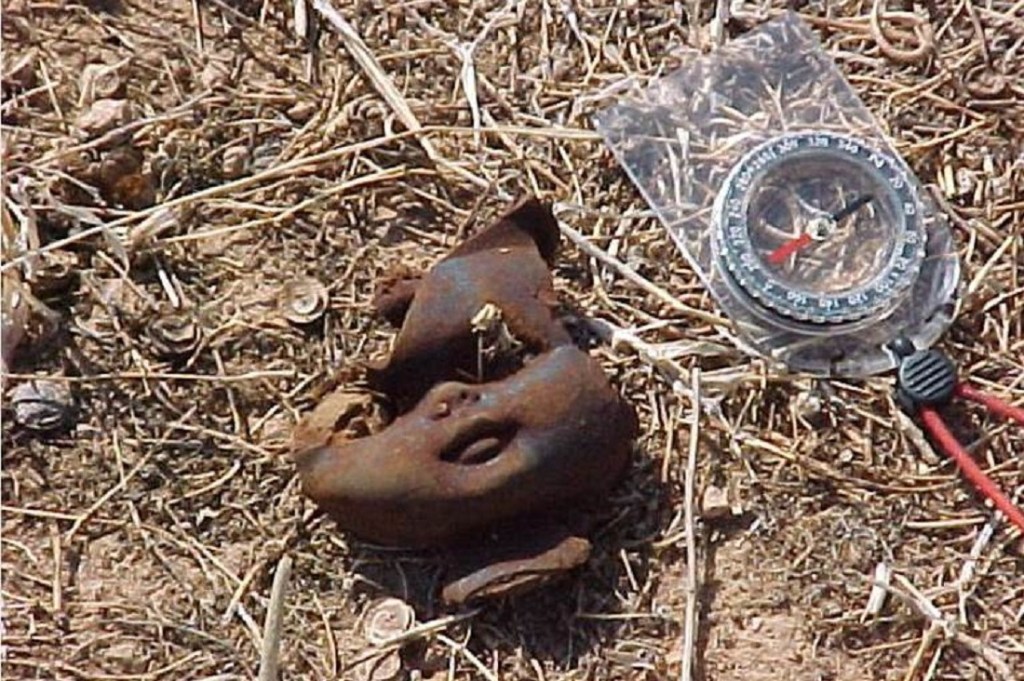
The Doll Heads of the Eastern Korinthia Survey

I no longer remember who found the first doll head in the Eastern Korinthia Archaeological Survey but the discovery brought the unique artifact type to the attention of all. Now it may be that the doll heads were simply denser in the territory we were surveying that season–the Isthmus east of Hexamilia, after all, has substantial modern dumps–but I suspect it was also a case of that documented phenomenon that surveyors find what they are trained to notice. In any case, the summer of 2001 was the season that walkers increasingly discovered, collected, and conversed about Corinthian doll heads.

ekas_dollheadEKAS_dollheads2
There were two things that especially bewildered surveyors about the doll heads. First, the bodies were nearly always missing. It is true that we did find entire plastic play figures in the field such as this torso (left) of the batman figure discovered in 2000, which followed one field team around in their treks through the landscape. But baby dolls (almost) never came with their bodies–the converse of that pattern that Roman statues are so consistently missing their heads.

Second, the dollheads seemed to come in every imaginable shape and size. There were big-head dolls with red hair, small dolls with petite faces and long foreheads, small-headed dolls with Medusa-like hair expressing surprise, and flat-faced sun-darkened dolls without hair.

EKAS_dollheads2ekas_dollheads4

If we had discovered these dolls in 1999, there might have been some attempt to collect, analyze, and chronotype them. That was the first year of the survey, and the project initially intended to record in a somewhat systematic way all the modern objects of the landscape. That was a novel idea, which proved impractical on the first day of survey when surveyors noted that plastic Loutraki water bottles (and other modern trash) was found in every unit of the survey territory. Modern ceramic material, not all material, became the principal signature of the modern period in EKAS. There is no reason, however, in principle, that the doll heads could not have been incorporated into our database of finds using our standard taxonomy for describing and typing artifacts. I’m imagining something like this

DollheadsCT

And it certainly would have been interesting to see the distribution of these objects in respect to modern settlement patterns.

By the end of the 2002 season, the doll heads had begun to have strange effects on the field teams. The dolls followed the teams around which means that someone must have collected them. Understand that archaeological survey encourages somewhat different interpersonal interactions than does, say, an excavation trench. Excavation allows for sustained conversation over long periods in a small space. In survey, walkers are spaced 20-40 feet apart and stare at the ground the whole time; conversation is shorter, banter is common. I think it was in this context that the doll heads — ghastly in their disembodied states, scarred by plowing, and corroded by the elements — became part of the running dialogue of the season and entered our discussion about archaeological survey.

Were the doll heads of the Eastern Korinthia “background noise” with an unclear relationship to the modern sites of the region? “Off-site” trash that originated from nearby settlements and was spread on fields through deliberate manuring? Toys dropped by children who accompanied their parents to the field during agricultural season? Or ritually deposited apotropaic objects designed to ward off negative spirits?

The doll heads also became part of an end-of-season plot to sabotage another field team’s near perfect record of collecting the fewest number of rocks (the ceramics teams kept tallies of which field teams mistakenly collected the most number of non-artifacts). At the end of season survey pottery, a presentation revealed how the doll heads carried out the attack and destroyed the good reputation of an archaeological team.

ekas_dollheads5ekas_dollheads6 ekas_dollheads7ekas_dollheads10ekas_dollheads8 ekas_dollheads9

Thanks to my EKAS colleague Tom Tartaron for jarring this repressed memory by requesting the extraction of these priceless photos from deep within the EKAS digital archives.

Forthcoming Publications of the American School of Classical Studies

I received a little pamphlet in the mail on Saturday about forthcoming publications of the ASCSA in 2016. Since some of these have been in production for years, I’ll save more detailed comments until the works actually appear in print. Forthcoming books include studies from Corinth, Isthmia, and the Nemea Valley, as well as the revised site guide to Corinth. I have provided links to the press pages for each book.


The Socio-Environmental History of the Peloponnese during the Holocene

Those who like their history long should be interested in this new article in Quarternary Science Reviews on environmental and human change in the Peloponnese over the last 9,000 years. Co-authored by fifteen historians, archaeologists, geographers, and geologists, the article aims to relate a range of climatic data with archaeological data to discern the relationship between environment and human settlement  during the Holocene.

  • Weiberg, Erika, Ingmar Unkel, Katerina Kouli, Karin Holmgren, Pavlos Avramidis, Anton Bonnier, Flint Dibble, et al. “The Socio-Environmental History of the Peloponnese during the Holocene: Towards an Integrated Understanding of the Past.” Quaternary Science Reviews. Accessed January 12, 2016.

 
The comparison  of data over many regions and long stretches of times means that the environmental records do not neatly match up with the archaeological data. The authors identify social and political factors as most significant than economic factors, and reject the notion that better climate always meant greater settlement. The article, while inconclusive, is nuanced and cautious, and devotes discussion to the challenges of doing such coarse comparisons, especially in respect to regional variation and chronology. Here’s the abstract:

Published archaeological, palaeoenvironmental, and palaeoclimatic data from the Peloponnese in Greece are compiled, discussed and evaluated in order to analyse the interactions between humans and the environment over the last 9000 years. Our study indicates that the number of human settlements found scattered over the peninsula have quadrupled from the prehistoric to historical periods and that this evolution occurred over periods of climate change and seismo–tectonic activity. We show that societal development occurs both during periods of harsh as well as favourable climatic conditions. At some times, some settlements develop while others decline. Well-known climate events such as the 4.2 ka and 3.2 ka events are recognizable in some of the palaeoclimatic records and a regional decline in the number and sizes of settlements occurs roughly at the same time, but their precise chronological fit with the archaeological record remains uncertain. Local socio-political processes were probably always the key drivers behind the diverse strategies that human societies took in times of changing climate. The study thus reveals considerable chronological parallels between societal development and palaeoenvironmental records, but also demonstrates the ambiguities in these correspondences and, in doing so, highlights some of the challenges that will face future interdisciplinary projects. We suggest that there can be no general association made between societal expansion phases and periods of advantageous climate. We also propose that the relevance of climatic and environmental regionality, as well as any potential impacts of seismo-tectonics on societal development, need to be part of the interpretative frameworks.


The Western Argolid Archaeological Project

The Canadian Institute in Greece has updated its digital archive of archaeological projects and research with content on the Western Argolid Regional Project. The summary includes information on personnel, survey type, five-year research plan, description of study area, detailed research goals, methodology, maps, and references. Images from the 2015 season are included with the report.

If you missed the WARP 2015 season, the team actively blogged about their work on the project website. The project is establishing a new standard of survey that combines fine-grained mapping of artifact distributions–the hyper-intensive–with substantial territorial coverage of landscapes. Over two seasons, field teams have surveyed over 13 sq km of territory using relatively small survey units–and the third season promises to add another 6 sq km to that total. In this sense, WARP improves on previous work by projects such as the Eastern Korinthia Archaeological Survey, which captured fine-grained distributions but only at limited coverage (ca. 4 sq km).

Coming Soon: Rural Lives and Landscapes in Late Byzantium (Gerstel)

Landscape approaches to the Byzantine world are still uncommon these days despite the increasing integration of regional approaches into ancient and medieval studies generally. It is gratifying, then, to see that another work dedicated to the subject of Byzantine landscapes will be out in print this month. Sharon Gerstel’s book looks delightful  in its combination of different sources of evidence and its abundant illustrations: churches of Attica, the Peloponnese, Crete, and Aegean islands; archaeological survey data from the Pylos region; and the local memory through ethnographic work in Greek villages. Here are some of the details:

Rural Lives and Landscapes in Late ByzantiumGerstel, Sharon E. J. Rural Lives and Landscapes in Late Byzantium: Art, Archaeology, and Ethnography. Cambridge University Press, 2015. 


Table of Contents:

1. The landscape of the village
2. Communication and the village church
3. The village woman
4. Village men, village labor
5. In the service of the church
6. The body and the soul.

Description:

“This is the first book to examine the late Byzantine peasantry through written, archaeological, ethnographic, and painted sources. Investigations of the infrastructure and setting of the medieval village guide the reader into the consideration of specific populations. The village becomes a micro-society, with its own social and economic hierarchies. In addition to studying agricultural workers, mothers, and priests, lesser-known individuals, such as the miller and witch, are revealed through written and painted sources. Placed at the center of a new scholarly landscape, the study of the medieval villager engages a broad spectrum of theorists, including economic historians creating predictive models for agrarian economies, ethnoarchaeologists addressing historical continuities and disjunctions, and scholars examining power and female agency.”

Limited excerpts of texts and images are available via Google Books.

Ten Unexpected Stories of Corinthian Archaeology, 2014

Cozied up at a country house near Granville, Ohio, my family ushered in the new year watching Robert Zemeckis’ Back to the Future II. This movie was a blast from the past. Released in 1989, I was a 15 year old skateboard punk when the film came out, and I distinctly recall conversations with friends about the (im)possibilities of the “hoverboard” – a wheel-less skateboard that floats on air (one of my friends claimed to have ridden one). In the second movie in the series, Doc Brown and Marty McFly travel 30 years into the strange future of 2015 with flying cars, hoverboards, automatic shoelaces, video conferencing, drones, accurate weather forecasts, and biometric scanners. This visit to 2015 causes a disruption of the space time continuum when the antagonist Biff Tannen borrows the time machine, visits his youthful self in 1955, and creates a new dystopian past and present (which alters the future 2015, of course), which resolves itself ultimately in the year 1885. No doubt Back to the Future II will be a hit this year: there are already a number of stories and videos like this one from the Washington Post, which compare the 2015 depicted in the film with the 2015 of our day.

Some of the stories of Corinthian Archaeology in 2014 remind me a bit of the strange world that the 1985 Marty McFly encounters when he travels 30 years into the future. There’s a kind of improbable, unexpected, or futuristic ring to them from the perspective of classical archaeology practiced a generation ago. How many archaeologists working in the Corinthia in, say, 1984, imagined that the following news stories would comprise the major archaeological events of 2014? If our time traveling archaeologist of 1984 had visited the year 2014 and stolen some tools and returned to the past, imagine the mayhem this would have created for the space time continuum.

Since it’s that time of year to compile lists of the greatest archaeological finds of 2014 (see, for example, this one from ASOR and this one from Archaeology magazine), it seemed fitting for Corinthian Matters to publish a ranking of the top ten unexpected stories of 2014. None of the stories below focus on new archaeological discoveries of 2014, which will not appear in journals anyway for at least several years, and none focus on new scholarship that made a splash last year, although your friends at Corinthian Matters are busily updating the Zotero library as we speak and will unleash a slew of new articles and books in the next couple of weeks. The stories below, rather, relate to the archaeological practice of Mediterranean archaeology, and are ranked not by their overall intellectual ramifications or importance per se – although many of them have already had an impact on archaeological knowledge – but according to their shock value – the “Great Scott!” of Doc Brown – from the vantage point of the past. Focusing on archaeological practice, I have had to exclude some pretty awesome stories like daredevil Red Bull pilot Peter Beneyei flying through the Corinth Canal twirling and whirling and plunging and looping. All the same, the ranking in its own way provides some view of the shifting landscape of archaeological practice today, especially as technology has crept into archaeological craft. Now I respect that you might arrange this list in a different order, or might substitute one story for another but here’s the AUTHORITATIVE list of Corinthian archaeology stories (where “Corinthian archaeology” is archaeology that has something to do wi5h the Corinthia).

10. Zigzag Art Discovered in the Panayia Field in Corinth

This story was certainly unexpected. It was one of the most widely circulated but least significant stories of the year which has to be included because it hit so many archaeological channels. The short piece from Live Science highlighted “Zigzag Art” on Geometric vessels from a sarcophagus of Corinth dating to the early 8th century BC. Zigzags are great, but are not overly impressive on Geometric vases (zigzags carved by early humans on 500,000 year old shells, on the other hand, are pretty cool). The author missed the major story – outlined in this recent report in Hesperia – about the early technological achievements of the Corinthian population. Still, the Panayia field excavations got some fine media attention. That the archaeological work reported in the Hesperia article and news piece was carried out a decade ago shows how long it can take for archaeological knowledge to reach the public and why it’s hard to put together a top ten list of discoveries of Corinthian archaeology in 2014. We may not know for many more years the full significance of what archaeologists documented last year.

9. The World’s Largest Solar Boat Arrives in Corinth

Ms-Turanor-PlanetSolar-departs-Monaco-27-September-2010-Photo-courtesy-of-PlanetSolarThis one also I didn’t see coming, but like the zigzags, got a lot of press. In July, the world’s largest solar-powered boat, “Tûranor PlanetSolar,” visited the port of New Corinth for several days and then sailed through the Canal. Operated by researchers from the Swiss School of Archaeology and the Greek Ministry of Culture, the catamaran was on an archaeological enterprise to the Argolid to conduct an underwater survey in search of a putative prehistoric settlement near Franchthi Cave. The boat was equipped with geophysical survey equipment that would map the seabed. The scale of the solar ship, as well as the technology employed for underwater survey, make this story worthy of report even though the archaeological work fell well outside the realm of the Corinthia. I never did hear what they discovered. See also coverage at  this site.

8. Good Luck for the Eutychia Mosaic at Corinth

Screenshot (23)In August, the ASCSA announced plans to restore the Eutychia mosaic through a generous donation. The organization provided this update in October. The restoration of a mosaic is not improbable per se from the vantage point of 1984 (conservation work was taking place at the great monochrome mosaic at Isthmia in the 1980s), but was nonetheless unexpected, and deserves to make the list given its significance for Corinthian archaeology and the publicity of the process (see no. 2 below). The Eutychia mosaic was originally uncovered in excavations of the South Stoa in the 1930s and has in recent decades been enclosed in a dark room off limits to visitors in the southeastern corner of the forum in Corinth. It’s that mosaic you can never really make out when you peer through the fence surrounding it. Since Broneer’s excavation, the mosaic has been interpreted as part of the office of agonothetes: the mosaic show a victorious athlete with a goddess holding a shield inscribed with eutychia, or “Good Luck.” It’s great that Betsey Robinson’s recent article in Hesperia publicized the need for restoration work, and also cool that that the work was recorded with video and publically released in tandem with the conservation.

7. Western Argolid Regional Archaeological Project Begins

P1070124As a landscape archaeologist, it’s inevitable that at least one survey project would make this list. Several friends and collaborators from the Pyla-Koutsopetria Archaeological Project and the Eastern Korinthia Archaeological Survey teamed up to launch a new distributional survey in the western Argolid with an acronym – WARP – that competes with any survey project of Greece and Cyprus. I had the good fortune of visiting this beautiful survey territory, the Inachos Valley, in the opening days of the project. Now, this isn’t the Corinthia per se, but the team contained so many Corinthian archaeologists that it seemed right to include the project in the rankings. Plus the project came on strong in the blogsophere with committed bloggers like Bill Caraher and Dimitri Nakassis pumping out interesting social media on a daily basis. The idea of a survey is not that unexpected of course from 1984, when some of the major surveys of Greece were fully in motion. Nonetheless, WARP gives us an example of an efficiently run hyper-intensive survey. As their abstract for a conference paper describes their work, the project surveyed some 5.5 sq km using very intensive distributional survey methods in a single season – greater coverage, that is, than the 4 sq km covered by the Eastern Korinthia Survey over three seasons (although EKAS was beleaguered by permit problems). If WARP is this efficient over the next two seasons, the project may end up one of the most efficient, intensive surveys projects carried out in Greek lands.

6. American School Launches New Maps and Spatial Data

Screenshot (27)It’s hard to know whether our classical archaeologist of 1984 would have imagined how important the GIS revolution would be for archaeologists of the future. The concept and technology for geographic information systems was established by the mid-1980s but commercial GIS software did not become widely available until the 1990s. Today archaeologists cannot live without it. In September, the ASCSA announced the dedication of a page populated with free GIS data, which continues to grow into a one-stop shop for free downloadable files related to Greece and the Peloponnese: digital elevation models, roads and cities, topographic contours, and ready made maps. I got to tour a beta version of this page in late August and had planned to blog the news release but the arrival of a little baby boy in early September changed that. This news certainly deserves a place on the list since it makes a major contribution to many different engagements on Corinthian archaeology. I will soon update the maps section of this site to point to this site.

5. The Lechaion Harbour Project Launches

One of the most exciting stories of the year was the launching of the Lechaion Harbour Project (LHP), a Danish-Greek enterprise designed (according to the project’s Facebook page) “to digitally survey, excavate, study, and publish the submerged archaeological remains of Corinth’s main harbor town Lechaion.” Some of the news outlets wrongly reported that Lechaion’s harbor had been discovered (it had never fully been lost). The real story was the use of such sophisticated equipment to map the underwater remains at Lechaion and – this is important – a systematic archaeological study of the harborworks. The project released a series of updates and mini-reports via its Facebook page about the process of an underwater digital survey through the use of dredges and a “3D parametric sub-bottom profiler” (sounds futuristic?). See this brief report from Archaeology magazine, this longer one from The Greek Reporter, and the original press release.

4. Michigan State University Wins NEH grant for Archaeological Resource Cataloging System

ARCS notebook

This story didn’t circulate as widely as I expected it would, but when the news release comes from was the prestigious National Endowment for the Humanities, you know it’s big. Dr. Jon Frey of Michigan State University was awarded a Digital Humanities Implementation grant on the order of $324,586 to develop and expand a tool called Archaeological Resource Cataloging System (ARCS) for digitizing the excavation notebooks at Isthmia, Nemea, Tauric Chersonesos, and Polis (Cyprus). ARCS is an open-source application for preserving and interacting with excavation notebooks and other field documents. This is a boon not only to Corinthian archaeology but also for smaller archaeological projects that are trying to record and preserve data on limited budgets. It’s also unexpected from our vantage year 1984. For a review of grant awarded, see this post, and Dr. Frey’s comments here.

3. The American School Launches its Virtual Field Trip App to Corinth

2014-08-25 09.21.32After a fifty year hiatus in publishing edition after revised edition of the official guidebook to Corinth and its museum, the American School of Classical Studies at Athens announced the imminent publication (now in production) of a seventh edition of Ancient Corinth: A Guide to the Site and Museum, plus – and here’s the kicker – a now available digital tour of Ancient Corinth via the Field Trip app available for iPhones and Androids. As I wrote in my review of the product, the Field Trip app enhances and greatly changes the user’s experience of Corinth. Visitors to the site who make use of the app can jump in and out of tour from anywhere on site (freeing them from the linear tour of the old guidebooks) and – really cool – anyone anywhere in the world can “tour” Corinth. This kind of public and digital archaeology product deserves a high rank not only for being unexpected a generation ago but also for making a major contribution to the study of ancient Corinth.


****************************************************************************

Now, ranking two most unexpected stories of 2014 was a tossup. It could have gone either way, but this is, I think, the right order, if you accept that the last one qualifies.

2. Corinthian Archaeologists Record Excavations of Frankish Quarter with Google Glass

corinth_2014season1026wearableglasses

This one knocked my socks off. In April the ASCSA announced that it was conducting its excavations of the Frankish quarter in Corinth using Google Glass. The excavations of the Frankish quarter marked their own interesting story, but were not surprising in their own right (excavations of the Frankish quarter began at Corinth in the late 80s). Yet the futuristic wearable technology in recording contexts (image left) takes the ASCSA Back to the Future (image right). Not sure that Google Glass will be the wave of the future, but this clearly marked one of the year’s most unexpected stories that expands upon a range of new directions in digital recording systems. As the ASCSA’s final news release describes the experience, “For our purposes, the students used Glass to create an interesting series of FPV (first person view) videos summarizing their excavations at regular intervals. This not only challenged them to present their excavations in a different medium but also forced them to question different audiences and how video might supplement the existing excavation record.” And my favorite quote: “Some [students] also found talking to their glasses disconcerting.” 

Some of these FPV videos are available on Google Plus:

This story certainly would have been number one unexpected story of the year had it not been for an even more bizarre story that narrowly edged it out.

1. Corinthian Archaeologists Excavate Atari Burial Ground in Alamogordo, New Mexico (and launch Punk Archaeology)

Atari-Graveyard-ControllerI really have few words for the winner. It was truly and completely unexpected. Even if our hypothetical archaeologist in 1984 had predicted all of the above, she/he could never have predicted that a group of archaeologists who had spent so much of their careers working in Greece would have been part of an excavation of a landfill in New Mexico to dig up the dump of the worst video game of all time, the 1983 Atari flop, E.T. New Mexico is a long way from the Corinthia, but three members of the archaeological team – Andrew Reinhard, Richard Rothaus, and Bill Caraher – were trained in Corinthian archaeology through ASCSA projects, published on Corinthian materials (in the case of Rothaus and Caraher), and (in the case of Reinhard) oversaw ASCSA publications. Some may disqualify this piece from Corinthian archaeology, but using the logic of association (see no. number 7 above), I think it deserves its place in the ranking. The story appeared in the major news outlets like Archaeology Magazine and CNN, and exploded in the blogosphere, so that even the ASCSA promoted (and has continued to promote) the story on its website. Two fun articles on this Atari dig include this one in Harper’s Magazine about the new punk archaeologists, and this one in The Atlantic by the punk archaeologists. This is not mainstream classical archaeology by any means, but rather “punk archaeology” – whatever that phrase means. Like the other stories outlined above, the run of the punk archaeologists in a New Mexico landfill offers another telling example of the unpredictable practice of archaeology today.

Daniel Stewart, on Rural Sites in Roman Greece

Bill Caraher’s review of Daniel Stewart’s recent article on Rural Sites in Roman Greece inspired me to plow through the piece this morning before turning to grading final exams and projects from my course in Historical Archaeology. I won’t repeat Caraher’s insightful points of review of the survey methods section of the article except to note that Stewart’s essay offers a selective, but valuable overview of the study of rural Roman Greece today. There’s an up-to-date bibliography, a good selection of trends in intensive survey method (in respect to Roman Greece), and excellent figures. As a table-lover, I enjoyed his tabular presentation of the periodization schemes for regional survey projects and the comparison of site classification by regional surveys.

On the broadest level, the article outlines the sorts of methodological and interpretive issues that are now vital to consider when studying the Roman landscapes of Greece. Stewart begins in the same place Susan Alcock began her work on Graecia Capta (1993)—with an outline of the problem of the picture of depopulation and decline presented by textual sources of Roman Greece. However, recognizing that this article was not the place to synthesize our knowledge of Roman rural Greece, Stewart sticks to a series of interpretative and methodological issues. Especially important are the concepts of dissonance and fluidity in human and archaeological landscapes:

“The landscape itself is an ephemeral thing: seemingly static but constantly in motion; appearing timeless but subject to radical morphological change. Though walking through a Greek landscape frequently feels like you are stepping through history, it is not the same landscape as that traversed by the inhabitants of Roman Greece. Even the coastline is different. The predominant material evidence itself is also unusual in archaeological terms: a partial surface reflection of subsurface remains that appear as a smear across the landscape, lacking depth, temporality and only crudely associated spatially. Most of what is recovered cannot be dated, only counted (for a summary of issues in landscape archaeology, see Stewart 2013b: 6–14). Unlike urban locales, the places where archaeological evidence exists are not even necessarily the foci of the most significant ancient behaviours – most of our evidence relates to agricultural production, storage and transport, yet these are ‘end-point’ evidence of behaviours that are focused on fields of crops or flocks of animals.”

A range of disjunctures and complexities separate us from past landscapes. In place of master narratives is regionalism, the recognition that things were different in different places. There is no single approach to studying rural landscapes but a multiplicity of “negotiations between the landscapes of the imagination and the physical landscapes we encounter in Greece.” While this is not particularly satisfying, Stewart’s piece neatly represents our new age of reflection on the problems and meaning of survey archaeology data.

My only quibble is that Stewart seems to downplay the value of literary sources. With many other scholars, Stewart notes that textual sources have created our principal interpretative problem for understanding rural landscapes of Roman Greece—the trope of depopulation and decline—and that intensive survey methods mark the best approach to studying landscapes. I value the contribution of regional survey, of course, but I have increasingly seen the value in more integrative approaches to bringing literature and material culture together in our studies of Roman Greece.

If you’re interested, Stewart has written more extensively on the subject in Reading the Landscapes of the Rural Peloponnese: Landscape Change and Regional Variation in an Early “Provincial” Setting. BAR International Series 2504. Oxford: Archaeopress, 2013.  I’ve added this to my January term reading list. Speaking of which, this brief post will be the last from me for the year. The other contributors to this blog may post, but I’m out on vacation. Happy holidays! We’ll see you in January.

A New Book on Rural Villas in Roman Greece

David Smith’s recent article in Archaeological Reports notes the publication of a new book titled Villae Rusticae: Family and market-oriented farms in Greece under Roman rule. Proceedings of an International Congress held at Patras, 23-24 April 2010. Edited by A.D. Rizakis and I.P. Touratsoglou, the publishers (Institute of Historical Research/National Hellenic Research Foundation) describe the content of the volume in this way:

“As that of other provinces of the Empire, the rural economy of Greece underwent many changes as well, with important implications for the strategies and organization of the production, as well as for the distribution and consumption of goods. Thanks to the extraordinary mass of archaeological data collected in Greece in the last decades, and to the possibility of applying both more sophisticated research instruments and more profitable methods of approach and analysis of these data, a re-examination of a regional case study such as Roman Greece is now more feasible. The publication in this volume of material remains – remarkable both for number and quality, from various in size productive complexes– and the synthetic studies on the other hand will provide students of the ancient world with an invaluable material which will greatly contribute to a better understanding of the economic organization of this part of the Roman Empire. It will also represent a point of reference for the study of both the rural world and more specific the economy of the cities of a small but not insignificant Roman administrative unit.”

Running 800 pages long, Smith may be right that Villae Rusticae will become “a standard text for the study of the rural economy of Roman Greece.”At the moment, however, there seem to be few libraries in the world that actually own a copy. I couldn’t find a loaning library in the U.S. via Interlibrary Loan, and the price is a hefty 120 €, plus shipping. An article or two are available for free on the National Hellenic Research Foundation website, and I found one or two more via Academia. It would be wonderful if the publisher would release a PDF version of the entire volume as they did with their Roman Peloponnese series.

The table of contents, available here, lists chapters mainly in Greek, with a few English, Italian, and French contributions.