Publishing the Eastern Korinthia Survey

One of the long-standing projects I have been working on over the last year is a book-length publication interpreting the results of the Eastern Korinthia Archaeological Survey. EKAS was a survey carried out from 1997-2003, with study seasons continuing to recent years. Unlike the more common survey project carried out in marginal territories or regions of small city states of antiquity, our work focused for the most part on the Isthmus of Corinth, one of the busiest and materially richest landscapes of antiquity. Although we made some forays into the southeastern region (with their own surprising results), our main work was on the Isthmus. That work has never been published in a systematic way. With the generous support of the project directors, I began last year to write up the results of the distributional survey.

Fieldwalkers line up on the Isthmus of Corinth in the first season of the EKAS Project in summer 1999

I spent a lot of time in fall refining survey data and also wrote the preface and six chapters. While I have some heavy lifting ahead of me (several period chapters still to write), I estimate that I’ve drafted about 70% of the work at this point — which puts the conclusion well within reach. Over the course of the year, I’ll be floating sections of the manuscript via this site and also writing a bit about some of the challenges of working with legacy data in artifact rich environments. For now, I include the table of contents and the opening part of the preface.

Table of Contents:

List of Illustrations ………………………………………………………………………………………………….  

List of Tables ………………………………………………………………………………………………….  

Preface ………………………………………………………………………………………………….

1. EKAS: A Twenty-Year Retrospective………………………………………………………………………………………………….

2. The Character of a Distributional Survey………………………………………………………………………………………………….

3. Archaeological Datasets………………………………………………………………………………………………….

4. Reflections on Surface Scatters……………………………………………………………………………………….

5. Patterns of Artifacts, Settlements, and Land Use……………………………………………………………………………………….

6. The Prehistoric Corinthia……………………………………………………………………………………….

7. The Protogeometric to Hellenistic Corinthia………………………………………………………………………………………………….

8. The Roman Corinthia………………………………………………………………………………………………….

9. The Medieval to Ottoman Corinthia………………………………………………………………………………………………….

10. The Modern Corinthia………………………………………………………………………………………………….

Preface:

Nearly two decades have passed since American archaeological field teams completed a major systematic survey of the eastern territory of the city of Corinth. The project, known as the Eastern Korinthia Archaeological Survey, involved over one hundred archaeologists, historians, geomorphologists, and student volunteers collecting cultural and environmental data over a span of six summers (1997-2003). As the first large-scale, intensive systematic survey of the Isthmus and Corinth’s southeastern territory beyond Mt. Oneion, EKAS promised to make significant contributions to Corinthian studies and the broader scholarship of Mediterranean landscape archaeology. The survey of the immediate territory of a major city of classical antiquity was unique in comparison with the more common studies of rural and remote regions of small Greek poleis. The project’s early adoption of innovative methods and tools, including tract-level mapping of artifacts, geomorphological assessments, an operative GIS, and database applications, made it significantly more intensive than other surveys in its day.

A formal and comprehensive publication was scheduled to appear in the years following fieldwork, but problems of execution and interpretation stalled immediate dissemination, while the project’s successes, including major new discoveries, generated trajectories of fieldwork that ultimately deferred analysis and publication. An important multi-authored preliminary report on the project’s methods came out in Hesperia in 2006 hinting at future sequels. An impressive array of individual publications appeared, offering discrete interpretations of particular sites or periods. The idea of a formal publication resurfaced again in 2015 as I was finishing my historical study of the Isthmus of Corinth and gained traction as we approached the twenty-year anniversary of the start of the survey. A plan was devised at last in 2018 with the support of the project co-directors (Timothy Gregory and Daniel Pullen), the field director (Thomas Tartaron) and other project participants (Bill Caraher, Dimitri Nakassis, and Lita Tzortzopoulou-Gregory), to publish the project’s findings in three distinct formats.

This works marks a systematic publication of the history, methods, datasets, and distributional analysis of the Eastern Korinthia Archaeological Survey. Published alongside online datasets, this digital-first book provides a view of patterns of settlement and land use at one of the most significant crossroads of the Greek peninsula from prehistoric times to the modern era. As such, it makes contributions both to Corinthian studies, which has tended to focus on the investigation of particular sites, and to Mediterranean regional survey literature that has most commonly considered the hinterlands of small cities. My scope in this work is an analysis of the surface artifact distributions of the territory, especially the Isthmus, a busy transport corridor with substantial settlements and sanctuaries from prehistoric times and the peri-urban district of a major polis during historic periods. The archaeological landscape has few parallels in mainland Greece or the Aegean basin: artifact-rich, high-density, and suburban. Like the survey work around small cities in Boeotia, Nemea, and elsewhere, this volume contributes especially to a corpus of literature dealing with the abundant landscapes of urban zones.

This book appears, secondly, in conjunction with a new publication of EKAS datasets (Pettegrew et al. 2021), released through Open Context (http://opencontext.org), a premier website for reviewing, publishing, archiving, and linking research data related to archaeological investigations. The cleaning and refinement of the datasets of the project itself constituted a magnus labor that occupied my attention full time over nearly two months during the pandemic. That cleanup was the precondition both for my analysis and the digital design of this study. The reader of this work will encounter project data at virtually every step—in a dedicated presentation of datasets (Ch. 3), reflections on survey data (Ch. 4), constant tabulated and geospatial analysis (Ch. 5-10), and hyperlinks to images of finds and contexts, scanned images of artifact drawings, original reports, data tables, and so on. The digital format provides in some places the option of drilling down to the underlying data and its spatial attributions. Nonetheless, the publication of EKAS datasets independent of this study means that the reader or user may view, browse, and download the findings directly at the Open Context website; someone with an interest in comparing regional surveys will find data readily available online and may use this book as a key to understanding it.

Finally, this comprehensive presentation of the framework and results of survey, together with datasets, establishes the foundation for a third final product of the survey now in the works: an edited volume presenting a series of essays from different authors interpreting survey results and the landscapes of the eastern Corinthia. While this current study adopts a unified voice and approach, the planned subsequent volume will feature multiple authors outlining the historical significance and interpretations of the discoveries and distributions of the project according to different frameworks and interests. This work, then, lays the groundwork for further interpretive studies of this historically busy region at the heartland of Greece and constitutes another building block toward historic landscape characterization of the territory.

A Week in the Corinthia

I recently returned from a week-long stint in the Corinthia. Every day I spent in the region was amazing. The weather was beautiful and perfect for archaeological fieldwork and the landscape was more stunning than I had remembered.

The research itself was rich, varied, and fruitful. I flew drones. I had coffee and lunch with friends, collaborators, and associates, which generated good conversations, leads, and new pathways. I visited the archives. I worked alongside a wildlife biologist who pointed out the rich landscape of Corinthian insect life that I had not paid too much attention to before. I walked again through the Greek countryside. I discovered things.

I won’t go into all the details here but will, if things go well, write in detail more about the projects this summer. In the meantime, here are some photographic snapshots of the week.

Church of Saint Paul in Ancient Corinth
Church of Saint Paul in Ancient Corinth. Photograph by David Pettegrew, May 27, 2018.


Saint Patapios icon at his monastery above Loutraki.
Saint Patapios icon at his monastery above Loutraki. Photo by David K. Pettegrew, May 27, 2018.

Flowers in a car at the Panorama restaurant on road to Perachora.
Flowers in a car at the Panorama restaurant on road to Perachora. Photograph by David K. Pettegrew, May 27, 2018.

Sunset over the Corinthian Gulf from the Panorama Taverna on road to Perachora.
Sunset over the Corinthian Gulf from the Panorama Taverna on road to Perachora. Photograph by David K. Pettegrew, May 27, 2018.

Photograph of the settlement of Lakka Skoutara in southern Corinthia,
Photograph of the settlement of Lakka Skoutara in southern Corinthia, by David K. Pettegrew, May 30, 2018.

Flying a drone over the trans-Isthmus wall on the Ayios Dimitrios Ridge. Photo by David K. Pettegrew, June 2, 2018.

Vineyard on Isthmus
Vineyard on Isthmus. Photography by David Pettegrew, May 28, 2018.

Beetle-browed Corinthia. Photograph by David K. Pettegrew, May 28, 2018.

Pegasus and a Fountain in New Corinth.
Pegasus and a Fountain in New Corinth. Photo by David K. Pettegrew, June 1, 2018.

The Church of Ayios Dimitrios on the ridge of the same name. Photo by David K. Pettegrew, June 1, 2018.

David Pettegrew, at Perachora, with view to Ancient Corinth. May 27, 2018.

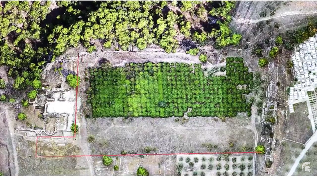
Digitizing and Droning Isthmia

Several years ago I wrote about the interesting work Professor Jon Frey of Michigan State University was doing with collaborators at Isthmia to digitize the excavation notebooks as well as the associated finds and context data. Over the last couple of weeks, MSU has spotlighted Frey’s recent work at the site including his discovery of a gymnasium at the site (now published in Hesperia, with Timothy Gregory).

The article, “Digital Dig: A New Discovery from Ancient Greece,” also includes a video of a drone survey at Isthmia carried out in the fall with James Herbst, Timothy Gregory, and others. This is a great example of innovative technology and digital tools shedding light on old data sets.

Here’s a taste of the cover piece:

Through the careful study of excavation records dating back some 40 years, Michigan State University’s Jon Frey has discovered an ancient gymnasium at the archaeological site of Isthmia, Greece.
 Frey and his team are performing a “digital dig” of sorts. Rather than using shovels and tools to excavate the site, the researchers are studying a backlog of evidence housed in remote storage.

“The neat part is there are many moments when we discover things that the original excavators missed,” says Frey, assistant professor of classical studies in the College of Arts and Letters. “So it’s kind of like our research has shifted from digging to detective work. We’re essentially re-excavating the archives.”

You can find additional videos about the work at Jon’s website, and The State News at MSU also did a separate writeup.

I embed one of the videos below.

The Isthmus from 20,000+ Feet

I always request a window seat when I fly in and out of Athens International Airpot on the hope of capturing good images of the Corinthia. Photographer and archaeologist Jacquelyn Clements shared with me the image below from her flight in December 2013 (and kindly gave permission to share on this site). The beautiful photo clearly shows the constricting neck that defined the Isthmus in antiquity. The ancients, of course, never had this particular aerial perspective of the Corinthian Isthmus but they did have a bird’s eye view from Mt. Gerania, Oneion, and Acrocorinth, as well as the practical experiences of coastal navigation. Until the later Hellenistic era, most Greek writers conceived of the Isthmus as the zone of greatest constriction between Akra Sousaki and Akra Sophia on the Saronic Gulf, and Loutraki and New Corinth on the Corinthian Gulf–the landscape shown in the photo below.

Photo by Jacquelyn H. Clements

Bridge of the Untiring Sea (Gebhard and Gregory, eds.)

I finally have my hands on Bridge of the Untiring Sea: the Corinthian Isthmus from Prehistory to Late Antiquityfresh off the press (December 2015) from the Princeton office of the American School of Classical Studies at Athens. I wrote briefly about this forthcoming book in June (here and here).

The Bridge has been a long time in the making. It began really with a half century of excavation and survey on the Isthmus (Broneer’s excavations began at Isthmia in 1952). A conference was held in Athens in 2007 celebrating that milestone, which proceeded quickly to chapters in 2008 before stalling out in a long period of revisions (my own chapter on Corinth’s suburbs went through at least eight drafts from conference paper to final proof). So this is a well-edited and thoroughly corrected collection, which means no reviewer should point out spelling mistakes and grammatical inconsistencies in my essay! As I haven’t seen hardly any of these essays since the original presentation in Athens, I’m excited to finally have a copy to read, especially since I’m wrapping up page proofs of another book on The Isthmus of Corinth.

UntiringBridge_m

The Bridge is a substantial book in paperback form, well-illustrated (160 figures) and carefully edited. It’s significantly smaller and about a third the weight of The Corinthia and the Northeast Peloponnese, another Corinthia conference published in 2014, which included 56 chapters and 558 pages on all aspects of the broad modern region of the Korinthia. While the editors’ introduction is short and efficient, the book just feels much more focused and coherent than The Corinthia and the Northeast Peloponnese with its sprawl of archaeological knowledge. The nearly 17 chapters and 400 pages of Bridge focus especially on the vicinity of the Sanctuary of Poseidon at Isthmia and, to some lesser extent, the broader region (technically the Isthmus, which has been generously extended in one chapter to the southeast Corinthia). Almost half of the essays (7 of 17) are devoted to the district of Isthmia in the geometric to Hellenstic periods (with chapters on subjects such as the Temple of Poseidon, the Rachi settlement, figurines, pottery, the Chigi Painter, and the West Foundation); another four chapters take on Roman subjects related to Isthmia (sculpture, agonstic festivals, Roman baths, East Field); there are a couple of Late Antique Isthmia essays (on lamps and the Isthmia fortress); and a few chapters consider the entire region (my piece on Roman settlement, Bill Caraher’s essay on the Justinianic Isthmus, and Tartaron’s piece on Bronze Age Kalamianos).

It’s worth noting that this is a collection of solid archaeological and (mostly) empirical essays on different facets of the history of the Isthmus, and especially the district of Isthmia. Some of the essays look like Hesperia articles with extensive catalogues and photos of artifacts. While the work’s scope provides “for the first time the longue durée of Isthmian history” (p. 1), covering the Mycenaean period to the end of antiquity, the editors do not attempt in the introduction (and there is no conclusion) to impose an overarching explanation or central thesis for the long-standing importance of the Isthmus through time. Rather, they offer a short discussion of its different values to ancient writers, an efficient overview of geography and topography of the broad Isthmus, a cursory history of research at Isthmia, and some discussion of recent research programs, publications, and approaches (which is only missing a substantial dicussion of recent efforts at digitization at Isthmia). What the introduction does establish is the long-lasting importance of the Isthmus in ancient thought and the important ties of the landscape to the city of Corinth — points that are discussed explicitly in many of the essays of the volume. But the essays largely stand on their own with little connection between.

In this respect, The Bridge of the Unitiring Sea should be most useful for Corinthian studies in its presentation of a series of state-of-the-field studies of different material classes (pottery, lamps, architecture, terracotta figurines) and sites, some of which are underpublished. Many of the scholars who have contributed essays to the volume have been engaged for years–decades, even–in archaeological research at Isthmia, the Isthmus, and Corinth and their material classes. The collection, for example, offers up-to-date assessments of the architectural development of the Temple of Poseidon, the history of settlement at Rachi, the West Foundation near Isthmia, the Roman bath, the mysterious “East Field” area near the Temple of Poseidon, and late antique lamps–most of which will form the subject of their own specialist publications in the future.

The work is valuable in a final respect in making available numerous up-to-date maps, plans, and illustrations: maps of the eastern Corinthia, the Isthmian district, the Sanctuary of Poseidon, and the Temple proper; maps of Bronze Age and Roman and Late Roman settlement in the Corinthia; state plans and restored views of the temple, sanctuary, and domestic architecture (at Rachi); reconstructed views of men at work; and dozens of photos of materials excavated at Isthmia.

As the Isthmus is central in so many ways to Corinthian history, this edited collection is a most welcome addition to the scholarship of the ancient Corinthia. And since the essays cover every period from prehistory to late antiquity (sadly, no medieval), and often consider the sanctuary’s relationship to Corinth specifically, this is a work relevant to anyone interested in ancient Corinth and Panhellenic sanctuaries.

Corinth Terraces Revisited in light of Digital Elevation Models

Several years ago, I posted a couple of pieces about the value of new satellite imagery for creating high-resolution topographic maps and digital elevation models of the Corinthia and the northeast Peloponnese. The imagery just continues to improve and with it new applications and potential for understanding landscape histories. This multi-Terracesauthored article published in September in Geotectonic Research revisits the geomorphic character and history of marine terraces of the Corinthia in light of newly available super-resolution satellite imagery:
  • De Gelder, G, D Fernández-Blanco, R Lacassin, R Armijo, A Delorme, J Jara-Muñoz, and D Melnick. “Corinth Terraces Re-Visited: Improved Paleoshoreline Determination Using Pleiades-DEMs.” Geotectonic Research 97, no. 1 (September 1, 2015): 12–14. doi:10.1127/1864-5658/2015-06.

As the authors argue in this brief (published conference) paper, available here, new Digital Elevation Models, which are accurate to within half a meter, allow significant enhancements over previous studies in understanding the history “of one of the most extensive and well-preserved terrace sequences in Greece.” So the authors conclude,

 With the quality of the Pleiades DEMs we are no longer limited by resolution and accuracy of the topographic information, since uncertainties in the relative contributions of erosion, climate, and tectonics now outweigh those in the data itself, providing an encouraging opportunity to re-evaluate the area. The quality of the Corinth DEM in combination with the TerraceM interface allows us to (locally) detect more terrace sub-levels compared to previous studies, and improve our constraints in finding the paleoshorelines. Apart from terrace analysis, possible future applications of these Pleiades DEMs –both in Corinth and in other locations– include the analyses of (active) faults, river drainages and sedimentary basins, all of which can greatly benefit from this new generation of high-quality topographic data.

Here’s the abstract for those who just want the summary:

The newest generation of satellites have greatly improved the capabilities of optical imagery over the last decade. Ground resolution has increased by one order of magnitude (to sub-metric pixel images), and improved sensors allow images to be located with an absolute accuracy of within a few meters. Better-resolved images facilitate refined tectonic studies of faults, basins, terraces, and other geomorphic features as it provides the opportunity to extract detailed topographic information. We have developed high-resolution digital elevation models (DEMs) in eight locations in Greece from tri-stereo satellite images acquired by the new Pleiades platform of CNES. With 0.5m resolution, these DEMs are state-of-the-art in comparison to previous DEMs made from satellite imagery. In this study we explore the potential of one of these DEMs, in the eastern Gulf of Corinth, for the analysis of a flight of marine terraces.

The Isthmus of Corinth Project (Coming Spring 2016)

One of the research projects I will not be working on all summer is my long-labored book, The Isthmus of Corinth: Crossroads of the Mediterranean World. I put the final touches on the manuscript during my fieldseason in Cyprus (with the Pyla-Koutsopetria Archaeological Project) just in time for the deadline with University of Michigan Press. I’m happy to report that the manuscript is now out of my hands at last and will enter the production queue with a scheduled publication of Spring 2016. That’s all good news of course since this project required a full sabbatical to complete along with the better part of my summers for the last three years. I’ve updated the project page to reflect the final state of the manuscript. There may be small changes in the next few months, but nothing major.

IsthmusAerial_KRP

Here is my description of the work from the project page:

The Isthmus of Corinth: Crossroads of the Mediterranean World is a study of the relationship of local, regional, and global interactions in the Roman Mediterranean. Its starting point is the ancient and modern view that the land bridge was a constantly connecting and essential landscape throughout Corinth’s history that altered its economy and character in consistent ways. From the destruction of the Greek city by the Romans to the end of antiquity, historians, poets, orators, and preachers characterized Corinth as an exceptional kind of maritime city made prosperous and powerful from its crossroads, facilities for traffic, commercial markets, pilgrim sites, naval fleet, and decadent pleasures.  The ancient consensus that a timeless landscape determined the history, wealth, and character of the city, was adopted almost wholesale by European travelers and the first classical and biblical scholars of the 18th-19th centuries.

The book argues against the timeless view of the Corinthian Isthmus and shows instead how the landscape changed frequently in its connection to a wider Mediterranean world. The chapters of the work survey the extant Greek and Latin literature for the Isthmus  and synthesize archaeological evidence, especially the data from the Eastern Korinthia Archaeological Survey. The chapters begin with the sixth century BCE and step in chronological increments to the fifth century CE.

The table of contents with brief summary:

List of Illustrations

List of Tables

Preface

1. Introduction

Outlines the problem of the essential or timeless view of the Corinthian Isthmus. Makes the argument for contingency.

2. The Isthmos

Surveys the conceptions and definitions of the isthmus in the Classical and Hellenistic era and offers a new interpretation of the famous passage in Thucydides about how the Isthmus made Corinth wealthy and powerful

3. The Gate

Surveys the physical landscape of fortifications and settlements that the Romans encountered in the late third century BCE. Outlines the physical developments of the regional structures from the archaic to Hellenistic periods, with special attention to the Eastern Korinthia Archaeological Survey data.

4. The Fetter

Surveys the central place of the Isthmus in the interpretation the Roman destruction of Greek Corinth and the great catastrophe of the loss of Greek freedom.

5. The Portage

Analyzes the changing historical significance of ship portages over the Corinthian Isthmus in antiquity. The center of the chapter is the remarkable portage of the orator Marcus Antonius, grandfather of the famous triumvir, in 102/101 BCE. The chapter contextualizes Marcus Antonius in light of the frameworks of Roman aristocratic values and imperialism during the interim period.

6. The Bridge

Studies the important place of the Isthmus for the first century of the Roman colony’s history. Offers a new interpretation of Strabo’s influential interpretation of the landscape.

7. The Center

A study of the meaning of canalization in antiquity, and especially the Emperor Nero’s failed canal effort. Situates Nero’s enterprise within the particular imperial frameworks of the 50s-60s CE. Also discusses the long-term effects of the canal enterprise on the landscape during the later first to early third centuries CE, including settlement documented in the Eastern Korinthia Survey.

8. The District

A study of the fragmentation of the essentializing conception of the Corinthian Isthmus in the later third to early fifth centuries, including the later Roman transformation of the panhellenic sanctuary at Isthmia.

9. Conclusion

****************************************************************

I’ll be posting more on this project in the coming weeks. Stay tuned.


Deserted Villages Session: AIA 2016

Another interesting conference session is in the works—this one for the 2016 meetings of the Archaeological Institute of America on the theme of “Deserted Villages.” I had never seen as much talk on FB about “abandonment” and “formation processes” as the day last summer when friends began to bandy about this session idea.

Proposed Colloquium Session for the 2016 AIA Annual Meeting, San Francisco, CA, January 6-9, 2016

Organizers: Deb Brown Stewart and Kostis Kourelis on behalf of the Medieval and Post-Medieval Archaeology Interest Group, Archaeological Institute of America

Deadline for Submission of Abstracts: March 13, 2015

The Medieval and Post-Medieval Archaeology Interest Group invites proposals for papers on the topic “Deserted Villages” for a colloquium at the next AIA Annual Meeting. Of particular interest are papers that feature post-classical sites (late-antique, medieval, or post-medieval villages) and that address:

– definitions of “village” (archaeological or ethnographic),

– new fieldwork or new interpretations of data,

– research that brings together diverse sources of data, and

– historic preservation concerns.

The selected proposals will shape a fuller abstract for the colloquium.

If you have a suitable paper or idea, please send (1) authors’ names, (2) institutional affiliations, (3) contact information, (4) paper title, (5) approximate length of time for your presentation (no more than 20 minutes), and (6) an abstract (no more than 400 words and conforming to “AIA Style Guidelines for Annual Meeting Abstracts”) by March 13th to Deb Brown Stewart, debbrownstewart@gmail.com

Corinth_June 12 021_m

Daniel Stewart, on Rural Sites in Roman Greece

Bill Caraher’s review of Daniel Stewart’s recent article on Rural Sites in Roman Greece inspired me to plow through the piece this morning before turning to grading final exams and projects from my course in Historical Archaeology. I won’t repeat Caraher’s insightful points of review of the survey methods section of the article except to note that Stewart’s essay offers a selective, but valuable overview of the study of rural Roman Greece today. There’s an up-to-date bibliography, a good selection of trends in intensive survey method (in respect to Roman Greece), and excellent figures. As a table-lover, I enjoyed his tabular presentation of the periodization schemes for regional survey projects and the comparison of site classification by regional surveys.

On the broadest level, the article outlines the sorts of methodological and interpretive issues that are now vital to consider when studying the Roman landscapes of Greece. Stewart begins in the same place Susan Alcock began her work on Graecia Capta (1993)—with an outline of the problem of the picture of depopulation and decline presented by textual sources of Roman Greece. However, recognizing that this article was not the place to synthesize our knowledge of Roman rural Greece, Stewart sticks to a series of interpretative and methodological issues. Especially important are the concepts of dissonance and fluidity in human and archaeological landscapes:

“The landscape itself is an ephemeral thing: seemingly static but constantly in motion; appearing timeless but subject to radical morphological change. Though walking through a Greek landscape frequently feels like you are stepping through history, it is not the same landscape as that traversed by the inhabitants of Roman Greece. Even the coastline is different. The predominant material evidence itself is also unusual in archaeological terms: a partial surface reflection of subsurface remains that appear as a smear across the landscape, lacking depth, temporality and only crudely associated spatially. Most of what is recovered cannot be dated, only counted (for a summary of issues in landscape archaeology, see Stewart 2013b: 6–14). Unlike urban locales, the places where archaeological evidence exists are not even necessarily the foci of the most significant ancient behaviours – most of our evidence relates to agricultural production, storage and transport, yet these are ‘end-point’ evidence of behaviours that are focused on fields of crops or flocks of animals.”

A range of disjunctures and complexities separate us from past landscapes. In place of master narratives is regionalism, the recognition that things were different in different places. There is no single approach to studying rural landscapes but a multiplicity of “negotiations between the landscapes of the imagination and the physical landscapes we encounter in Greece.” While this is not particularly satisfying, Stewart’s piece neatly represents our new age of reflection on the problems and meaning of survey archaeology data.

My only quibble is that Stewart seems to downplay the value of literary sources. With many other scholars, Stewart notes that textual sources have created our principal interpretative problem for understanding rural landscapes of Roman Greece—the trope of depopulation and decline—and that intensive survey methods mark the best approach to studying landscapes. I value the contribution of regional survey, of course, but I have increasingly seen the value in more integrative approaches to bringing literature and material culture together in our studies of Roman Greece.

If you’re interested, Stewart has written more extensively on the subject in Reading the Landscapes of the Rural Peloponnese: Landscape Change and Regional Variation in an Early “Provincial” Setting. BAR International Series 2504. Oxford: Archaeopress, 2013.  I’ve added this to my January term reading list. Speaking of which, this brief post will be the last from me for the year. The other contributors to this blog may post, but I’m out on vacation. Happy holidays! We’ll see you in January.