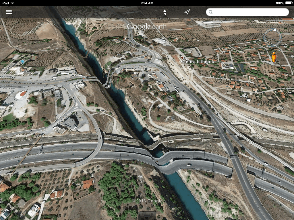
Elastic Roads

Google Earth provides excellent satellite imagery and aerial photographs of the Corinthia, but the service seems not to have done so well in reconciling the built features  of the landscape with the topography in the area of the Corinth Canal. My six-year old and I were flying around the Isthmus and discovered the distortion in imagery that makes the national highway and railway look like a themepark roller coaster. Have no fear: the roads over the canal are perfectly flat, or at least they were the last I checked.
photo 1
photo 2
photo 4

The Triton makes a Way

Photo by David Pettegrew, June 2, 2011.
The hopes of 19th century engineers that the Corinth Canal would become a major seaway for traffic from the Adriatic were frustrated by the growing size of seafaring ships from the early 20th century. This cruise boat has a tight squeeze. Photo by David Pettegrew, June 2, 2011.
Photo by David Pettegrew, June 2, 2011.

Hadji Mustafa

HadjiMustafa2
The guardian of the Ottoman fountain of Joseph the Tailor, aka, “Hadji Mustafa,” a source of fresh water for the village of Ancient Corinth. Photo by David Pettegrew, May 31, 2014.
HadjiMustafa
Hadji Mustafa, the fountain on the lower slopes of Acrocorinth. The monument dates to 1515. For more information on the monument, see this page at the ASCSA website and the Hesperia journal article for free download by Pierre McKay. Photo by David Pettegrew, May 31, 2014.

The View from St. Patapios

CorinthianIsthmusfromGeraneia
One of the best views of the Isthmus, the Oneion mountain spine, and the Corinthian coastal plain from the monastery of St. Patapios on Mt. Geraneia. Acrocorinth is visible on the right side of the image, beyond the white buildings of New Corinth. Lechaion visible at coast on the far right.

Ancient Corinth in the Digital Public Library of America

The Digital Public Library of America boasts an expanding collection of 11,000,000 images, books, and video from public libraries, archives, and museums around the United States. If you’re unfamiliar with this new resource, the DPLA is a portal and platform launched in 2013 that enables a user anywhere to discover cultural materials once locked up in public libraries across the country. As the DPLA website describes the organization:

The Digital Public Library of America brings together the riches of America’s libraries, archives, and museums, and makes them freely available to the world. It strives to contain the full breadth of human expression, from the written word, to works of art and culture, to records of America’s heritage, to the efforts and data of science. DPLA aims to expand this crucial realm of openly available materials, and make those riches more easily discovered and more widely usable and used, through its three main elements:

This short YouTube video offers a compelling overview of the DLPLA’s vision, mission, and scope. The project is a brilliant one that promises to create a longer-lasting and higher-quality digitization of cultural material with solid metadata than commercial giants like Google have done with Google Books.

IndexPlentiful Corinthian material is already available and one can imagine the material will grow rapidly. A word search on “Corinth, Greece” at the time of this post returns about a hundred hits for historic and recent photographs, stereo photo-negatives, plans, postcards, illustrations, old maps, novels, and archaeology and historical monographs in PDF. A search on “Corinth” returns over 1,300 hits although much of that material returns content related to particular American churches (e.g., Corinth Baptist Church) or towns in Mississippi and Vermont. But the relevant material includes private collections of photographs of Corinth, made widely available for the first time, and pdf versions of  scholarship such asCorinth VII.1 and Carl Blegen’s dissertation, to name a couple of examples.

As with most digital resources that cover such extensive ground, the metadata is uneven and depends on the investments made during the digitization process. Some records for the Corinthia have a full description about the source while others, such as the imaginative illustration of Corinth pasted above, lack the cues that could help the reader understand the illustration. The digital record is simply titled “Ancient Corinth,” tagged with a creation date of 1884-1885, and ascribed to John Clark Ridpath’s Universal history : an account of the origin, primitive condition, and race development of the greater division of mankind. (New York : Merrill Baker, c1899). I tracked found the original image in volume 1 of Ridpath’s earlier work, Cyclopædia of Universal History, which was published a full decade before excavations began at ancient Corinth.

Moreover, in extensive data resources like the DPLA, there’s always the risk of the loss of original context.  The imaginative vision of ancient Corinth, in fact, comes from a passage about the end of the Greek polis and the rise of Macedon. It is encased in 19th century nostalgia for a lost antiquity. It is almost wholly the work of imagination.

“The voice of the Greek, so shrill in battle so musical in peace; his gay activities, his energy, so often reviving from humiliation and ruin; his brush, his chisel–alas, for all these! where are they? The beauty of Athens has sunk into the dust. The wolves of Mount Taygetus howl in the Grecian communities, their failure in public spirit…For the present, it is sufficient to take leave, not without regret, of that brilliant dark among the broken stones of Sparta. The splendor of Corinth is no more. Only by the imperishable Thought–the verse of Homer, the page of Herodotus, the infinite spirit of Plato, the clarion of Demosthenes–has the renown of Hellas survived, illumining the world that now is, and shedding a glory over her name, even to teh far-off shores of the setting sun.”

This is not to downplay the tremendous asset of the DPLA for research and teaching purposes, but the visitor should use thsi resource aware of the quality of the metadata.