Category: Diachronic
-
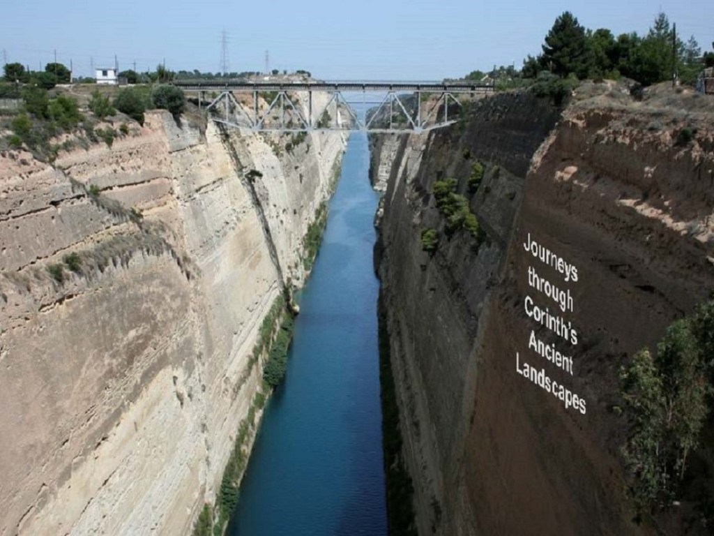
Journeys through an Ancient Landscape
I spent Thursday and Friday last week visiting St. Mary’s College of Maryland located on the beautiful site of Historic St. Mary’s City, which served as Maryland’s original state capital and ranks among America’s oldest colonial settlements. It was one of the most interesting campus visits I have had in combining my interests in ancient…
-
Bridge of the Untiring Sea (Gebhard and Gregory, eds.)
I finally have my hands on Bridge of the Untiring Sea: the Corinthian Isthmus from Prehistory to Late Antiquity, fresh off the press (December 2015) from the Princeton office of the American School of Classical Studies at Athens. I wrote briefly about this forthcoming book in June (here and here). The Bridge has been a long time in the making. It…
-
Ceramics, Cuisine, and Culture (Spataro & Villing, eds.)
This new edited collection devoted to the study of Mediterranean kitchen ware is a welcome development in the scholarship of ancient pottery, the most ubiquitous object unearthed in excavation and documented in regional surveys. Most publications on Hellenistic, Roman, and Late Antique pottery have focused on amphoras (storage and transport vessels), or fine table wares (for dining), material classes that were produced…
-
The Socio-Environmental History of the Peloponnese during the Holocene
Those who like their history long should be interested in this new article in Quarternary Science Reviews on environmental and human change in the Peloponnese over the last 9,000 years. Co-authored by fifteen historians, archaeologists, geographers, and geologists, the article aims to relate a range of climatic data with archaeological data to discern the relationship between environment and human settlement during the Holocene.…
-
The Western Argolid Archaeological Project
The Canadian Institute in Greece has updated its digital archive of archaeological projects and research with content on the Western Argolid Regional Project. The summary includes information on personnel, survey type, five-year research plan, description of study area, detailed research goals, methodology, maps, and references. Images from the 2015 season are included with the report. If you missed the WARP 2015…
-
Classical Archaeology in Context (Haggis and Antonaccio, eds.)
This new book published by Walter de Gruyter GmbH should be of wide interest for classical archaeologists who understand how particular contexts, theory, and method frame archaeological research, data, results, and conclusions at the end of the day. As one of the longest-running excavations in the Mediterranean, references to Corinth are plentiful. I am also…
-
The Isthmus of Corinth Project (Coming Spring 2016)
One of the research projects I will not be working on all summer is my long-labored book, The Isthmus of Corinth: Crossroads of the Mediterranean World. I put the final touches on the manuscript during my fieldseason in Cyprus (with the Pyla-Koutsopetria Archaeological Project) just in time for the deadline with University of Michigan Press. I’m happy to report that the manuscript is now…
-
Digitizing Isthmia with the Archaeological Resource Cataloging System (ARCS)
DKP Introduction: I noted yesterday that the National Endowment for the Humanities recently awarded Jon Frey, Assistant Professor of Art History & Visual Culture at Michigan State University, a major grant for the digital implementation of an open-source application known as the Archaeological Resource Cataloging System (ARCS). I asked Jon more about what his teams…
-
Major NEH Grant awarded for the Digitization of Excavation Records at Isthmia
It’s not every day that one sees friends and colleagues awarded hundreds of thousands of dollars to develop open-source applications for uploading, organizing, and sharing archaeological data and records. I was delighted last month when I saw the announcement circulate on FB that Dr. Jon Frey of Michigan State University received a Digital Humanities Implementation…
-
Touring Corinth (virtually) with the Field Trip App
About a month ago, Andrew Reinhard of the American School of Classical Studies at Athens announced a new digital tour of Ancient Corinth that accompanies the publication (in press) of Ancient Corinth: A Guide to the Site and Museum. The book, which will hit the market this fall, marks the first guidebook to Corinth published…
