Category: EKAS (Eastern Korinthia Archaeological Survey)
-

Publishing the Eastern Korinthia Survey
One of the long-standing projects I have been working on over the last year is a book-length publication interpreting the results of the Eastern Korinthia Archaeological Survey. EKAS was a survey carried out from 1997-2003, with study seasons continuing to recent years. Unlike the more common survey project carried out in marginal territories or regions…
-

Return to the Corinthia
This is not really how I had imagined I would return to Corinthian matters–bunkered down in my home near Harrisburg, Pennsylvania, in the midst of a global pandemic, working on this website while what’s left of Hurricane Zeta dumps rain on central PA. Only eight months ago, I was in the process of gearing up…
-

Corinthian Matters in Corinth
Corinthian Matters will be on its (mostly) annual tour to the Corinthia three weeks from now (May 26-June 2). I will only be in the Corinthia for a week this year because I have to get back for a digital proficiency workshop in early June, but that still allows seven full days of Corinthiaka goodness.…
-
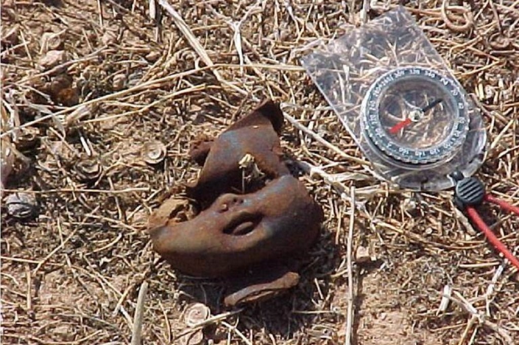
The Doll Heads of the Eastern Korinthia Survey
I no longer remember who found the first doll head in the Eastern Korinthia Archaeological Survey but the discovery brought the unique artifact type to the attention of all. Now it may be that the doll heads were simply denser in the territory we were surveying that season–the Isthmus east of Hexamilia, after all, has substantial modern dumps–but I suspect it was also a case of that documented phenomenon…
-
Bridge of the Untiring Sea (Gebhard and Gregory, eds.)
I finally have my hands on Bridge of the Untiring Sea: the Corinthian Isthmus from Prehistory to Late Antiquity, fresh off the press (December 2015) from the Princeton office of the American School of Classical Studies at Athens. I wrote briefly about this forthcoming book in June (here and here). The Bridge has been a long time in the making. It…
-
The Isthmus of Corinth (Coming Spring 2016)
To my surprise (and delight), I recently discovered via a Google Alert that my long-labored book on the Corinthian Isthmus had “gone live” on the interwebs. And yesterday, I received page proofs and instructions to return corrections and an index by February 25. The University of Michigan Press has posted this page to advertise the book and slated publication for June 15, 2016. But page…
-
The (Almost) Abandoned Village of Lakka Skoutara
Last Friday, the Medieval and Post-Medieval Archaeology in Greece Interest Group co-sponsored a colloquium in two sessions at the Archaeological Institute of America on the theme of “Deserted Villages.” The first session was devoted to the subject of villages before abandonment and included papers on “The ‘Dead Villages’ of Northern Syria” (Anna M. Sitz), “Village Desertion and Settlement Patterns in…
-
Coming Soon: The Eastern Korinthia Archaeological Survey Data
One of the projects I have been working on this summer is the publication and online presentation of the data sets of the Eastern Korinthia Archaeological Survey, an intensive archaeological survey of Corinth’s eastern territory carried out between 1997 and 2003. The EKAS project has been a frequent point of discussion here at Corinthian Matters, of course. Although the project covered a relatively…
-
The Isthmus of Corinth Project (Coming Spring 2016)
One of the research projects I will not be working on all summer is my long-labored book, The Isthmus of Corinth: Crossroads of the Mediterranean World. I put the final touches on the manuscript during my fieldseason in Cyprus (with the Pyla-Koutsopetria Archaeological Project) just in time for the deadline with University of Michigan Press. I’m happy to report that the manuscript is now…
-
Thirty New Roman Sites on the Corinthian Isthmus
I recently finished editing proofs of a chapter for the forthcoming book, “The Bridge of the Untiring Sea”: The Corinthian Isthmus from Prehistory to Late Antiquity”. The piece, which grew out of a paper I delivered in Athens in 2007, offers a new synthesis of settlement patterns on the Isthmus during the Early Roman (44…
